For decades, the world map used by French diplomats has shown a vast Greenland, an oversized Russia and a shrunken Africa. That is about to change. Foreign Minister Jean-Noël Barrot announced on Friday that the Quai d'Orsay will abandon the Mercator projection, the 16th-century cartographic standard that exaggerates landmasses near the poles and minimises those close to the equator.
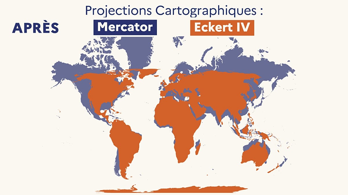
In its place, France will adopt the Eckert IV projection, a lesser-known equal-area map created in 1906. The switch means that on official French diplomatic maps, France itself will appear smaller relative to equatorial countries, as will the United States and Russia. The decision was announced during a speech at the Sorbonne, at the public event La Fabrique de la diplomatie.
A map is never neutral
Barrot argued that the Mercator projection, which most Europeans have seen since childhood, distorts geopolitical perceptions. "A map is never entirely neutral," he said. "The areas we see on it do not correspond to actual areas: the United States, Russia, China take on a disproportionate visual importance compared with Africa, Latin America or South-East Asia."
He highlighted the case of Greenland, which appears almost as vast as the entire African continent on Mercator maps, even though it is roughly the size of the Democratic Republic of Congo or Algeria. "Changing the map obviously does not change the world," Barrot added. "But correcting a representation that distorts it is already an act of truth."
The French move comes just hours after the United Nations General Assembly in New York voted to abandon the Mercator projection in favour of the Equal Earth model, a 2018 equal-area projection. The non-binding resolution, titled "Correcting the map" and sponsored by Togo, was adopted with 164 votes in favour. The African Union had already endorsed Equal Earth in March, and the resolution encourages other governments and institutions to follow suit.
Only the United States voted against, calling the initiative a "radical ideological project" because the text refers to "cognitive justice and memorial reparation" for cartographic distortions. Six countries—Estonia, Georgia, Lithuania, Moldova, Serbia and Ukraine—abstained.
The UN stressed that the resolution does not ban the Mercator projection, nor does it impose a single map. It simply encourages governments, schools, international bodies and tech companies to use equal-area projections that preserve true proportions.
France has chosen Eckert IV rather than the UN's recommended Equal Earth. Both are equal-area projections, but they differ slightly in how they render the shapes of continents. Eckert IV, designed in 1906, is a compromise that keeps landmasses recognisable while correcting size distortions.
In practice, the change will be gradual. Digital platforms such as Google Maps still rely on a version of the Mercator projection, and most French school textbooks continue to use it. Grégory, a senior history and geography teacher in Rennes, told Euronews that "you can find Eckert or Peters in some textbooks, but that is very rare."
The foreign ministry's shift may, however, influence educational materials. France has already taken steps to modernise its public imagery, and the debate over map projections is part of a broader conversation about how Europe sees the world. As the UN resolution suggests, the goal is not to erase Mercator but to offer a more honest picture of the planet.
For now, the change is symbolic but significant. It reflects a growing awareness that maps are not neutral tools, and that the way we draw the world shapes how we understand it. France's decision, though modest in scope, aligns with a wider European push for cartographic accuracy and cognitive fairness.