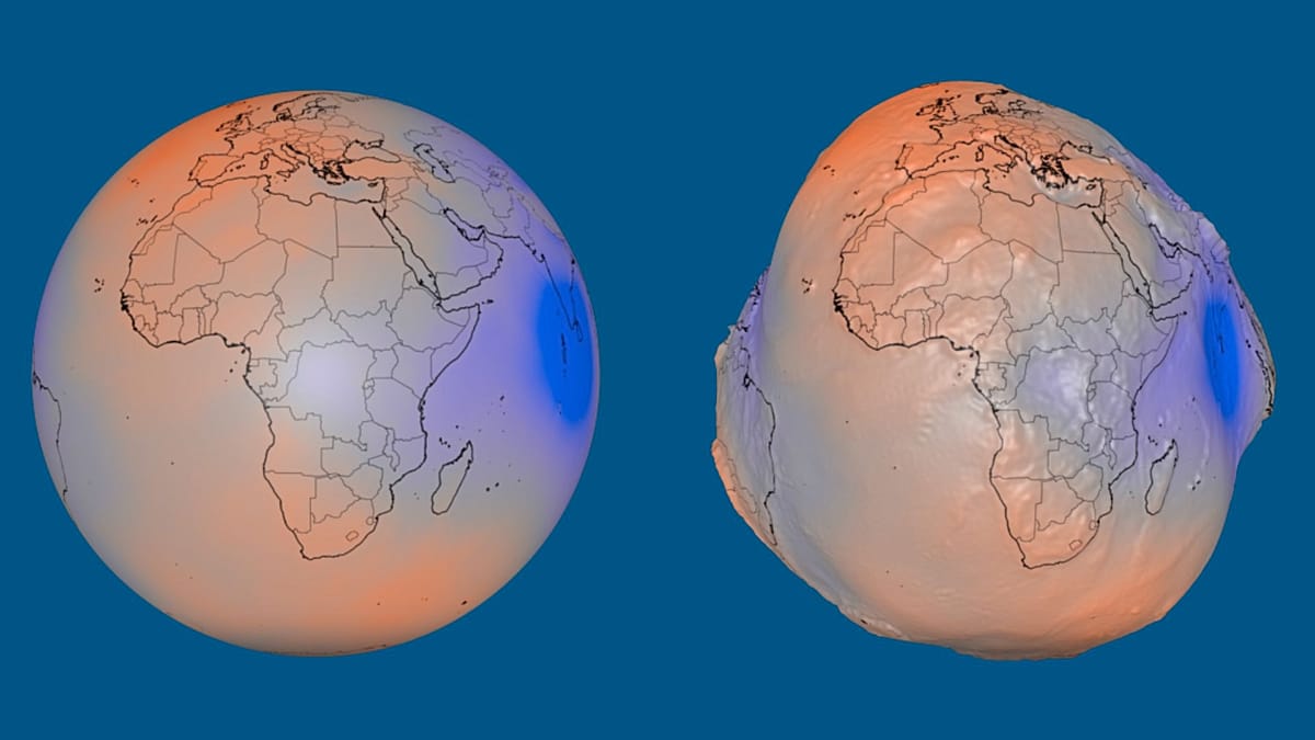
Gravity is not uniform across our planet, and that unevenness leaves a visible mark on Earth's shape. This summer, NASA released a striking visualization that highlights these differences, making our world look less like a perfect sphere and more like a lumpy potato.
The visualization depicts the geoid—a mathematical model of Earth's gravitational field that represents what the global ocean surface would look like if it were shaped only by gravity and the planet's rotation, with no tides, waves, winds, or currents. In this model, the sea surface is not smooth but features subtle bulges and depressions, which NASA has exaggerated by a factor of 10,000 to make them visible.
These variations arise because mass is distributed unevenly within Earth. Mountains, ocean trenches, and differences in the density of subsurface material all tug at the gravitational field. Where there is extra mass, gravity pulls water toward it, creating a rise in the geoid; where mass is lacking, the theoretical sea level dips.
From Iceland to India: the extremes
In reality, the difference between the geoid's highest and lowest points is 191 meters. The highest point sits about 85 meters above the reference level near Iceland, while the lowest plunges 106 meters below it south of India. The reference level is a smooth, slightly flattened mathematical model of Earth used as a baseline for these measurements.
The visualization is based on more than one billion observations collected by 19 satellites over 15 years, including NASA's Gravity Recovery and Climate Experiment (GRACE) and the European Space Agency's Gravity Field and Steady-State Ocean Circulation Explorer (GOCE). These missions have revolutionized our understanding of Earth's gravity field, with applications ranging from oceanography to geodesy.
While the geoid is not the actual shape of Earth's physical surface, it is a crucial tool for scientists. It helps define a precise 'sea level' that underpins GPS measurements, satellite altimetry, and climate models. For instance, understanding the geoid is essential for tracking sea-level rise, as it provides a reference against which ocean height changes can be measured.
For Europe, the geoid has particular significance. The European Space Agency's GOCE mission, which operated from 2009 to 2013, was a flagship Earth Explorer satellite that mapped the geoid with unprecedented accuracy. Its data have been used to improve our understanding of ocean circulation, which influences climate patterns across the continent, and to refine the European Vertical Reference System used in construction and land surveying.
The geoid also offers a window into the planet's interior. By studying its undulations, geophysicists can infer the structure of the mantle and crust, shedding light on processes like plate tectonics and volcanic activity. This knowledge is vital for assessing natural hazards, such as earthquakes and volcanic eruptions, which affect communities from Naples to the Azores.
As NASA and ESA continue to refine these models, the geoid remains a powerful reminder that our planet is far from uniform. It is a lumpy, dynamic world, and its gravitational quirks are a key to understanding how it works.